The Lynch Nolan Plan (LNP) Frequently Asked Questions
This page was created as a FAQ in response to the City Engineer's email about the Lynch Nolan Plan. See the City Parking Plan page. To add a comment contact us here. Or post to The Fringe Element fb page.
The City Engineer says: City Council Mandate: Spaces in the LNP are 9’x18’ and do not meet the Council requirement.
The spaces in LNP were slightly shorter due to rounding error in the drawing technology used, as explained in the appendix. We feel that the overall space used is within 2-3% of the target space. Assume the Engineer is right and take away 5% of the spaces to account for this error. Remaining spaces in the lots = 2304 – 128 spaces = 2176 spaces remaining.
The City Engineer says: Eliminating Morrie Moss / Prentis would pose significant traffic and ped/bike safety challenges for patrons of both the park and the zoo. The City Engineer says: Pedestrian refuge areas and walks are minimally addressed.
Not true. Morrie Moss and Prentiss are retained and reconfigured as driveways or access ways within the parking lot, and south of the Zoo, Morris Moss is retained as is. Pedestrian, bicycle and emergency vehicle access is retained at the northern park terminus of Morrie Moss, and pedestrian access is possible via the Greensward and N McLean. Eight pedestrian walkways (the blue lines) are provided in the north-south direction and dedicated walkways are provided along the current east-west Prentiss line, which are envisioned as protected from the adjoining traffic lanes, and also on the northern boundary east of the Zoo Plaza, as well as along the western boundary and an additional pathway from the Prentiss south-eastern point to the tip of Zoo Plaza. Where the blue lines cross parking space areas, there is a 9’X38’ pedestrian refuge, which can be protected by small trees or concrete structures. There are 28 of these pedestrian refuges plus several smaller ones.
The City Engineer says: The LNP reroutes park patrons all the way around Poplar to North Parkway.
This is untrue. Patrons coming from Arkansas and from points east via Sam Cooper naturally use North Parkway, and the gridlock on N McLean suggests the majority of patrons arrive by these routes. Those who come from the south and who currently use the Poplar / Morrie Moss park route would travel north via Danny Thomas, Cleveland, Evergreen, McLean or East Parkway to N Parkway and don’t have to drive on Poplar at all. The only patrons who have to drive on Poplar would be those who originate on Poplar. There is no reason for patrons to approach from Poplar if they know that the entrance is on N. Parkway. We can’t protect Zoo patrons from doing dumb stuff.
The City Engineer says: Long drive aisles upwards of half a mile around the parking lot will pose challenges that will result in worsening the traffic condition in the area.
Not true. The 22’ access spaces double as two-way drive aisles. The perimeter at the current southeast end of the main lot has space for a perimeter driveway, or for trees if desired. Additional north-south 18’ drive aisles would cost about 12 parking spaces in the current Prentiss area and 36 spaces in the center of the main lot. Deduct 48 spaces for two additional connecting drive aisles. As the general traffic flow is east to west, the only time drivers would have to go in another direction would be if they drive past all open spaces and have to recirculate. Electronic signage throughout the parking lot, showing how many open spaces lie west of the sign, will help drivers not to pass the last open spot.
When the lot is loaded up in the morning we don’t expect shopping mall behaviors, where drivers circulate in search of a spot that was vacated since their first pass. These drivers know that spots won’t be vacated anytime soon, so they will park before the lighted sign that says 'zero spots available ahead'. The design expects the vast majority of drivers to make one efficient east to west pass during their stay at the Zoo. The only significant time when there is roughly balanced entering and exiting traffic is during the lunch time customer changeover, but the electric signage should discourage recirculation.
Remaining spaces in the lots = 2176 – 48 spaces = 2128 spaces remaining.
The City Engineer says: when the LNP is overlaid with existing footprint of parking area it shows expansion east, beyond our scope area, and potentially requiring significant number of trees to be removed. Our desire is for the parking solutions to be integrated into the Overton Park experience, not a segregated solution. To do this end, we must provide safe and thoughtful access, to and through, and around the parking lot.
 The additional area to the east of the main lot is an area which the Zoo currently uses for employee parking. They put this area in service as a parking lot in 2016 when faced with space shortages in the existing lots. This area was put in service during the mediation process, to replace employee parking in the regular lots, and by the Zoo’s choice. The Zoo deployed this area stealthily without public announcement, and its use for parking was the Zoo’s choice.
The snip from Google Maps shows cars parked on a crushed rock surface in this area, and, not visible here, cars are also parked along paved roadways in the area to the left, covered by trees in this shot.
It clearly falls within the mandate of the current design process, as the area is used sub-optimally and cars are parked haphazardly. The space has room for about 170 cars and rarely parks more than 50 at present. The current planning process can use this space. The Council resolution does not forbid use of this area and explicitly provides wide latitude to the planning process and the administration to alter the outline plan as required. If you removed this area’s approximately 170 adjusted spaces, Remaining spaces in the lots = 2128 – 170 spaces = 1958 spaces remaining.
Additionally, the Zoo parking lot is never going to be a park feature. It is by nature an ugly intrusion into the park. It needs to be sequestered and visually hidden from the rest of the park, as envisioned in the resolution.
The City Engineer says: City Council Mandate: Tree Preservation is minimal in the LNP.
There are approximately 60 trees of more than 12” in the lots. We allowed 90 spaces to keep existing large trees. The 718 tees the Engineer mentioned includes hundreds of small trees, recently planted, most of which can be removed into the pedestrian walkways, at the ends of rows and around the perimeter as a visual screen. Take an additional 150 spaces to accommodate the existing large trees. 1968 – 150 spaces = 1808 spaces remaining.
With all the deductions in response to Manny’s comments, the 1818 remaining spaces are 336 more spaces than required for the plan. Most of the deductions, insofar as parking spaces or Greensward are sacrificed, should be considered optional. You could use the remaining spaces for parking or for planting or retaining up to 84 trees.
The glaring and obvious error in the XYZ plans are the reduction of inbound traffic lanes from the current two to one, as suggested in the resolution. Currently, with both N McLean and Morrie Moss used for inbound traffic, cars gridlock in both directions. They use something more than the capacity of two traffic lanes. The only change made to improve traffic flow in the XYZ plans is the elimination of one bottleneck or queueing point at the parking shack. The XYZ plans do not present the sort of traffic counts and Markov analysis required to prove that removing half the capacity and one bottleneck will result in an improved throughput solution. There are other queueing points in the system, including the traffic lights at McLean and N Parkway , lights at Poplar and Morrie Moss, the left turn at McLean and Prentiss for southbound traffic, the left turn on Morrie Moss at the alligator gate. As the speed limit in the park is 15MPH as opposed to 35MPH on N McLean, the slower approach will have less capacity than the N McLean lanes removed from the system. A thorough analysis is required to validate this traffic plan. An experiment could be performed by closing the Prentiss entry point for one busy weekend day, thus forcing all traffic to use the future Morrie Moss route. Our prediction is for gridlock extending to Poplar, and at least to the Poplar intersections with N McLean and E Parkway.
Our N Parkway entrance was formerly used as the main entrance to the Zoo, decades ago, according to the memories of residents.
Emergency vehicle access.
The LNP plan provides for unobstructed emergency vehicle access via an automatic barrier at the pedestrian Morrie Moss entrance, and also on the main access route, where the 12’ surfaced driveway and 8’ crushed rock shoulder allows for vehicles to pull over to allow an emergency vehicle to pass. Emergency vehicle access is provided for in the current Fire Department plan for the internal Zoo area, but the current plan needs to provide for unobstructed emergency access to the parking lot, which would be problematic with the XYZ plans.
LNP's new access route.
The new access route envisioned in the LNP could be dropped from the plan without affecting the parking capacity of the plan. Its addition is to enable access from the largest contiguous road system, N Parkway, with its I-40 access on the west and Sam Cooper on the east. Once past the N Parkway junction and the short drive to the existing Zoo works entrance, it is a continuous one lane road plus shoulder that goes straight to the parking lot without intersections, and which is entirely on Zoo property.
The City resolution in Exhibit A, in points 4 and 6, make Morrie Moss the only one-way entrance, and Prentiss/McLean the only one way exit. As such, traffic capacity planning is a part of the design process.
Traffic noise in the Old Forest.
Traffic noise on the inward Zoo access road is a factor. This could be ameliorated by adding sound deadening fence between the road and the Zoo boundary line, where the existing fence is. Overton Park and the Old Forest exist in an urban setting. The Old Forest pathways that are near the Parkway traffic already have traffic noise. The pollution aspect is improved as there should be little traffic backup in the park proper, in contrast to the XYZ plans.
How we envision the LNP plan to be used.
 An amended LNP plan, with or without the eastern annex, with or without the N Parkway entrance and with or without the noted adjustments clearly shows that the required 415 parking spaces, and a whole lot more, can be accommodated in the existing Zoo footprint. It’s going to be ugly anyway. The park needs to be visually screened from it. So how it looks doesn't matter.
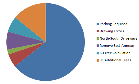
The pie chart to the left represents the 2304 spaces in the LNP, and the other colors represent one choice for the 1022 extra spaces. They follow the rebuttals of the Engineer's response in the rest of this FAQ.
The truth of the matter is that we are in a fight over the use of scarce resources. This is a common type of mathematical problem called a "Pareto Optimization" where stakeholders must decide the priorities. These problems are typically constrained by hard constraints (the 415 spaces and inviolability of the Greensward are hard constraints). Everything else are soft constraints. They have value to some stakeholders and the only real negotiation possible is the relative priority of the soft constraints.
We have only one priority: #NotOneInch. It is not necessary to take any of the Greensward. We regard this as non-negotiable, like the Zoo and the City consider the additional 415 spaces are not negotiable. By 'monetizing' the problem in terms of the 2304 possible spaces, the soft constraints can be discussed, relative priorities negotiated and a final plan agreed. This can be a discussion. Violating the hard constraints will cause a fight and result in a non-feasile solution. The engineers should understand this.
Back to the LNP main page.